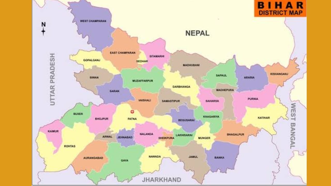
Bihar, a state in eastern India, holds a significant place in the country’s history and geography. It shares both international and state boundaries, which shape its cultural, economic, and political relationships. Understanding Bihar’s boundaries is important for students, especially those preparing for competitive exams like UPSC, BPSC, or other state-level exams. In this blog post, we’ll explore Bihar’s international and state boundaries, presented in an easy-to-understand format.
International Boundary of Bihar
Bihar shares a 729 km long international boundary with Nepal, which lies to the north of the state. This boundary plays a crucial role in trade, cultural exchanges, and even migration between the two regions. Seven districts in Bihar are directly connected to Nepal. These are:
- West Champaran
- East Champaran
- Sitamarhi
- Madhubani
- Supaul
- Araria
- Kishanganj
The proximity to Nepal makes these districts vital for international trade and cross-border cultural ties. This international border also requires stringent security to prevent illegal activities like smuggling.
State Boundaries of Bihar
Bihar is centrally located and shares boundaries with several Indian states, fostering interstate relations that are key to its economic and social fabric.
1. Boundary with West Bengal
To the east, Bihar shares its boundary with West Bengal, another crucial state in eastern India. This boundary stretches across three districts of Bihar:
- Kishanganj
- Purnea
- Katihar
These districts play a significant role in transportation and commerce due to their proximity to the West Bengal border, which connects Bihar to major ports and trade hubs.
2. Boundary with Jharkhand
Jharkhand, which was carved out of Bihar in 2000, lies to the south of Bihar. The two states share a cultural and economic history, and today, seven districts of Bihar share their boundary with Jharkhand:
- Bhagalpur
- Banka
- Nawada
- Jamui
- Gaya
- Aurangabad
- Rohtas
This southern boundary is important for the exchange of resources like minerals, as Jharkhand is rich in coal and iron. The region is also a significant trade route between the two states.
3. Boundary with Uttar Pradesh
To the west, Bihar shares its boundary with Uttar Pradesh, one of India’s largest states. This boundary influences both states’ cultural and economic exchanges. Eight districts in Bihar share their border with Uttar Pradesh:
- Rohtas
- Kaimur
- Buxar
- Bhojpur
- Saran
- Siwan
- Gopalganj
- West Champaran
This boundary serves as an essential route for transportation and trade between northern and eastern India.
Districts Without State or International Boundaries
Not all districts in Bihar share a border with other states or countries. There are 15 districts that lie within the heart of Bihar and are bordered only by other districts within the state. These are:
- Darbhanga
- Samastipur
- Vaishali
- Sheohar
- Khagaria
- Saharsa
- Madhepura
- Begusarai
- Munger
- Lakhisarai
- Sheikhpura
- Nalanda
- Jahanabad
- Arwal
- Patna
These districts form the core of Bihar’s internal administrative and economic functions. They are critical in maintaining the internal harmony and economic balance within the state.
Significance of Bihar’s Boundaries
The boundaries of Bihar are not just lines on a map; they represent the state’s interaction with neighboring states and countries. The international boundary with Nepal makes Bihar an important player in Indo-Nepal relations, with frequent exchanges in trade, culture, and even tourism. On the other hand, Bihar’s state boundaries facilitate economic growth and transportation, especially along the borders with West Bengal, Uttar Pradesh, and Jharkhand.
Bihar’s location, with access to Nepal and multiple Indian states, positions it as a strategic hub in India’s eastern region. Understanding these boundaries helps students appreciate Bihar’s geographic importance and its role in shaping both domestic and international relations.
Conclusion
| Boundary of Bihar | Details |
|---|---|
| International Boundary | Bihar shares a 729 km boundary with Nepal. 7 districts share their boundary with Nepal: West Champaran, East Champaran, Sitamarhi, Madhubani, Supaul, Araria, and Kishanganj. |
| State Boundaries | |
| Boundary with West Bengal | Bihar shares its eastern boundary with West Bengal. The 3 districts sharing this boundary are Kishanganj, Purnea, and Katihar. |
| Boundary with Jharkhand | Located to the south of Bihar, Jharkhand shares its boundary with 7 districts: Bhagalpur, Banka, Nawada, Jamui, Gaya, Aurangabad, and Rohtas. |
| Boundary with Uttar Pradesh | Bihar’s western boundary is shared with Uttar Pradesh. The 8 districts sharing this boundary are Rohtas, Kaimur, Buxar, Bhojpur, Saran, Siwan, Gopalganj, and West Champaran. |
| Other Districts | There are 15 districts in Bihar that do not share a boundary with any state or country: Darbhanga, Samastipur, Vaishali, Sheohar, Khagaria, Saharsa, Madhepura, Begusarai, Munger, Lakhisarai, Sheikhpura, Nalanda, Jahanabad, Arwal, and Patna. |
The boundaries of Bihar, both international and interstate, play a crucial role in defining its geography, culture, and economy. For students, learning about these boundaries is essential to understand how Bihar interacts with neighboring states and countries, and how it contributes to the nation’s overall growth. Whether it’s the cross-border relations with Nepal or the state boundaries that encourage trade and transportation, Bihar’s geographic location is central to its significance in India.
